Gulf of Alaska Ecosystem Observatory
Location of the Data
The Need
The Northeast Pacific, including the Gulf of Alaska, is expected to undergo transformative changes over the next century as warming continues and episodic El Nino and marine heat-wave events, such as “the Blob,” amplify temperature effects on the ecosystem. These changes in the physical environment can initiate a cascade of biological consequences that reduce an ecosystem’s resiliency (ability of the system to withstand disturbances) and increase its vulnerability to detrimental impacts (extent of harm from stressors). Given that the seafood industry in Alaska ranks third behind the petroleum industry and the federal government for generating economic activity, a solid understanding of the marine ecosystem and how it is impacted by variability in the physical, chemical and geological environment is needed to protect and manage Alaska’s ocean resources.
Moored oceanographic data from the GAK1 inshore mooring at the entrance to Resurrection Bay reveal that at a minimum, 10-20 years of continuous observations are necessary to fully capture the dynamic range of the nearshore physical variability. By extension, the same will be required to assess associated biogeochemical responses. Establishment of the northern Gulf of Alaska Ecosystem Observatory (GEO) will improve the ability to monitor, document and understand the important environmental conditions and ecosystem linkages that are changing on seasonal and annual time scales.
Project Location
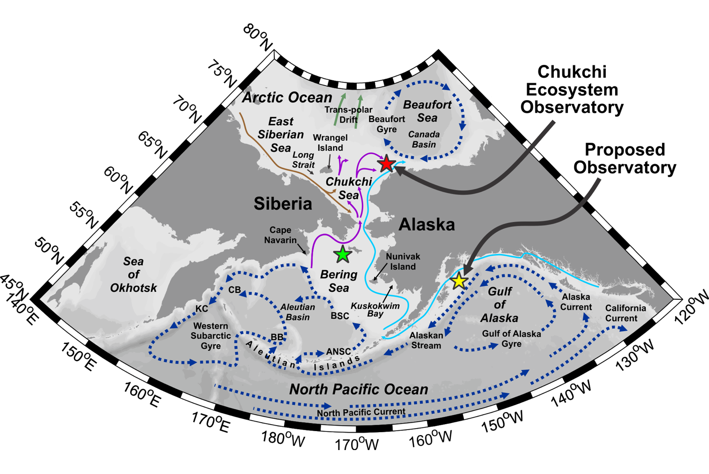
AOOS’s plan to establish sentinel ecosystem moorings in each of the Large Marine Ecosystems (LMEs) in Alaska designates moorings in the Gulf of Alaska, the Bering Sea, the Chukchi Sea and the Eastern Beaufort Sea. The general location for each observatory is selected based on the biological, economic, and cultural importance associated with each region and is founded on how each site is positioned to document the effects of shelf-canyon exchanges that regulate biological production, biodiversity, and community structure (see map). Establishing this modern-era observing consortium is at the forefront of expanding the Alaska-region marine observing capacity, providing the research and resource and fisheries management communities with unparalleled, long term datasets for discovery and improvements in ecosystem modeling.
The GEO sits near the shelf-break along the Seward Line, which supports a long time-series shipboard survey line that dates back to the 70’s.
Project Details
The GEO mooring is focused on providing the following critical, integrated information that will allow assessment of several important ecosystem functions:
- Quantifying how changes in temperature, salinity and ocean stratification impact chemical and biologic systems;
- Measuring particulate fluxes to the seafloor that supply the benthic community with organic matter;
- Establishing baseline acoustic data to determine presence and density of nekton (i.e. fish and mesozooplankton) while complementing other direct sampling and acoustic surveys in the region;
- Enabling a core station for the monitoring of ambient marine noise, vocal marine mammals and vessel sounds;
- Providing a basin anchor station for quantifying long term ocean acidification trends in the Gulf;
- Measuring changes to the shelf’s nutrient and carbon cycles on multiple time scales, from tidal to seasonal to decadal periods;
- Estimating how changing wind, waves, and currents affect the regional oceanography on those same time scales;
- Providing real-time data on one or more of the GEO moorings and the opportunity for complementary projects [e.g., Long Term Ecological Reserve (LTER)] to follow adaptive sampling strategies when working in the vicinity of the observatory;
- Providing real time data inputs for ocean-atmospheric models, ecosystem and ocean acidification models, and weather forecasts;
- Establishing the core database that will validate biogeochemical models and improve understanding of the marine carbon pump and shelf-basin exchanges.
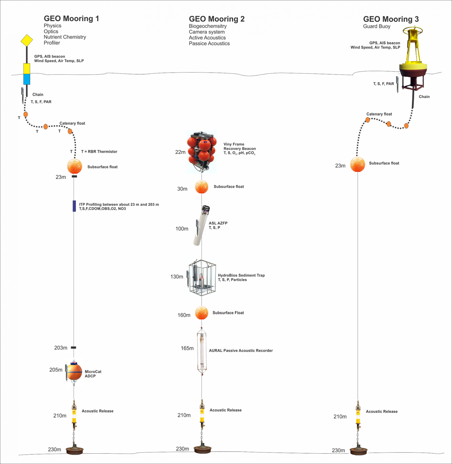
A diagram of the planned moored observatory in the northern Gulf of Alaska is shown in the following diagram.
| Measurements | Measurements | Sample Depth(s) | Temporal Resolution |
|---|---|---|---|
| TRDI ADCP | Current velocity & 150 KHz signal strength | 200-20 m (4 m bins) | 1 hr |
| TRDI ADCP | Current velocity & 600 KHz signal strength | 3-24 m (1 m bins) | 1 hr |
| TRDI ADCP | Temperature & Pressure | 24 m | 1 hr |
| ASL AZFP | 38, 125, 200 & 455 KHz Acoustic Backscatter | 1-100 m (10 cm bins) | 20 s |
| Multi-Electronique AURAL | Marine Mammal Vocalizations & Underwater Vessel Noise | N/A | 1 hr |
| Seabird SeaCat & Ancillary sensors | Temperature, Salinity, Pressure, Colored Dissolved Organic Matter, Optical Backscatter, PAR, Chlorophyll-a Fluorescence | 25 m | 1 hr |
| Satlantic SUNA | Nitrate | 25 m | 1 hr |
| Contros HydroC | Partial Pressure of CO2 | 25 m | 1 hr |
| SeaBird SeapHOx | pH, Dissolved Oxygen, Temperature, Salinity | 25 m | 1 hr |
| Seabird MicroCat | Temperature, Conductivity, Salinity | 240, 150, 50 & 0 m | 15 min |
| HydroBios Multi Sediment Trap | Chloropyll a, Phytoplankton species, Total particulate organic carbon & nitrogen, Zooplankton species & fecal pellets | 100 m | 7 days to 4 weeks |
Projects Highlights
The project will be implemented in a three-stage process to bring the moored observatory online.
- During the build-out stage (2018-19), the equipment was purchased, outreach conducted, site selection was finalized, and the mooring design was completed.
- PIs consulted with commercial fishermen from Seward, Homer, and Kodiak who helped guide which locations will experience reduced risk of fouling fishing gear on the mooring.
- A surface buoy with a flashing light and Automatic Identification System (AIS) beacon is planned for the mooring, which will greatly increase the in situ visibility of the mooring and should preclude all unintended fisheries interactions.
- During stage two (2019-20), the frames were fabricated and equipment affixed to the mooring line as the gear is tested and readied for deployment.
- The first mooring array was successfully deployed in July 2019 from the R/V Sikuliaq.
- The mooring array will be deployed for 12 months and then recovered and replaced with a duplicate and identical set of moorings the following year.
- Vessel support for the mooring operations will be provided by the Gulf of Alaska LTER program.
- The GOE1 mooring from the array was successfully redeployed during the May 1-4, 2020 Seward Line survey, after having been recovered by R/V Sikuliaq in April 2020 due to a failure to communicate real time. This mooring includes a repeat-profiling system that will routinely measure temperature, salinity, chlorophyll-a fluorescence, colored dissolved organic matter (CDOM), nitrate (NO3), and dissolved oxygen (DO) throughout the water column for the next year.
Funding Sources & Partners
Operational support for the observatory is highly leveraged through the following programs:
> The M.J. Murdock Charitable Trust
> AOOS Core Program 2018-2021
> University of Alaska Fairbanks
> Exxon Valdez Oil Spill Trustee Council
> National Science Foundation
Other Collaborations
This project augments ongoing stock assessments and ecosystem monitoring programs that are funded by the Exxon Valdez Oil Spill Trustee Council (EVOSTC), the North Pacific Research Board (NPRB), and the National Science Foundation (NSF). Observations from the GEO will add to these programs by providing data during times of the year when no other program is conducting surveys. In addition to direct funding support, in-kind support from the following programs, through ship time and technical support, are helping make the GEO possible:
- NSF Northern Gulf of Alaska (NGA) Long-Term Ecological Reserve (LTER)
- EVOSTC Gulf Watch Alaska (GWA) Program
- NPRB’s Long-term Monitoring (LTM) Program
Resources
- Northern Gulf of Alaska, Long Term Ecological Research
- Seward Line Project
- GAK1 Mooring Time Series, Resurrection Bay, Alaska
Publications
National Strategy for Sustained Network of Coastal Moorings 2017. McArthur, S., Bailey, K, Janzen, C, Morrison, R., Murphy, T., Newton, J., Ruberg, S., Send, U.
https://cdn.ioos.noaa.gov/media/2017/12/NationalStrategyforSustainedNetworkofCoastalMoorings_FINAL.pdf
Principal Investigators
University of Alaska, Fairbanks, CFOS
University of Alaska, Fairbanks
University of Alaska, Fairbanks, CFOS

University of Alaska, Fairbanks, CFOS
University of Washington,
Applied Physics Laboratory
University of Alaska, Fairbanks, CFOS
University of Alaska, Fairbanks, CFOS

University of Alaska, Fairbanks, CFOS
