Prince William Sound Sentinel Climate & Weather Observations
Location of the Data
The data collected at SNOTEL sites are transmitted to a central database where they are used for water supply forecasting, maps, and reports.
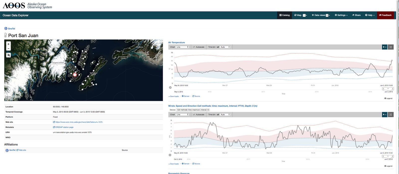
Data from the SNOTEL stations are also picked up by AOOS from the NRCS server and delivered as part of the real time sensor network on the AOOS Ocean Data Explorer data portal.
The Need
As part of the Snow Survey and Water Supply Forecasting (SSWSF) Program, the National Water and Climate Center (NRCS – under the U.S. Department of Agriculture) administers an automated snow monitoring program consisting of several types of automated and semi-automated data collection methods. The SNOTEL (SNOw TELemetry) network is composed of over 800 automated data collection sites located in remote, high-elevation mountain watersheds across the western U.S. including Alaska. They are used to monitor snowpack, precipitation, temperature, and other climatic conditions. SNOTEL stations are capable of measuring both liquid and solid precipitation, making them a valuable part of all-season weather monitoring in the Alaska. Additionally, they provide local real time weather data, such as air temperature, barometric pressure, and wind speed/direction.
With AOOS funding, eight SNOTEL meteorological stations were set up in 2004 and since maintained around Prince William Sound in Southcentral Alaska, in partnership with NRCS and the Oil Spill Recovery Institute (OSRI). These stations measure precipitation from snow and rain throughout the year and are needed to establish the freshwater budget for the area. They also collect much needed weather observations in the region. Understanding the circulation of Prince William Sound requires accurate measurements of wind fields and precipitation. The SNOTEL weather measurements are, therefore important for oil spill trajectory modeling. Snowmelt runoff and rainfall create a freshwater surface layer that sets up aspects of the surface circulation. Wind stress also modifies the regional circulation and influences both short term and seasonal circulation patterns. Understanding the basic meteorological conditions, including precipitation, advances the ability to model the hydrology of Prince William Sound, improves understanding of the forces driving seasonal changes in circulation, and provides oil spill response organizations with the necessary information for them to be successful. The array also provides a much broader network of weather observations for mariners, improving environmental maritime domain awareness in one of the heaviest boating traffic regions in the state. The weather data are also valued by aviators and outdoor enthusiasts.
Project Location
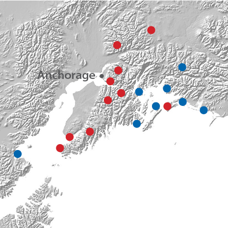
AOOS specifically supports operations and maintenance of the SNOTEL stations in and around the Prince William Sound area and Cook Inlet. Since the summer of 2004, six SNOTEL stations have been deployed at sea level in the Prince William Sound and Cook Inlet regions, and two stations at higher alpine elevations.
AOOS supported SNOTEL stations include:
- Strawberry Reef – PWS
- Mt. Eyak – PWS
- Tatitlek – PWS
- Port San Juan – PWS
- Seal Island – PWS
- Esther – PWS
- Sugarloaf – PWS
- McNeil River – W. Cook Inlet
There are currently over 75 active SNOTEL stations operating real time across Alaska. Data for all regional SNOTEL stations are available on the AOOS Ocean Data Explorer data portal through the Real Time Sensor Map, including terrestrial-based stations.
Project Details
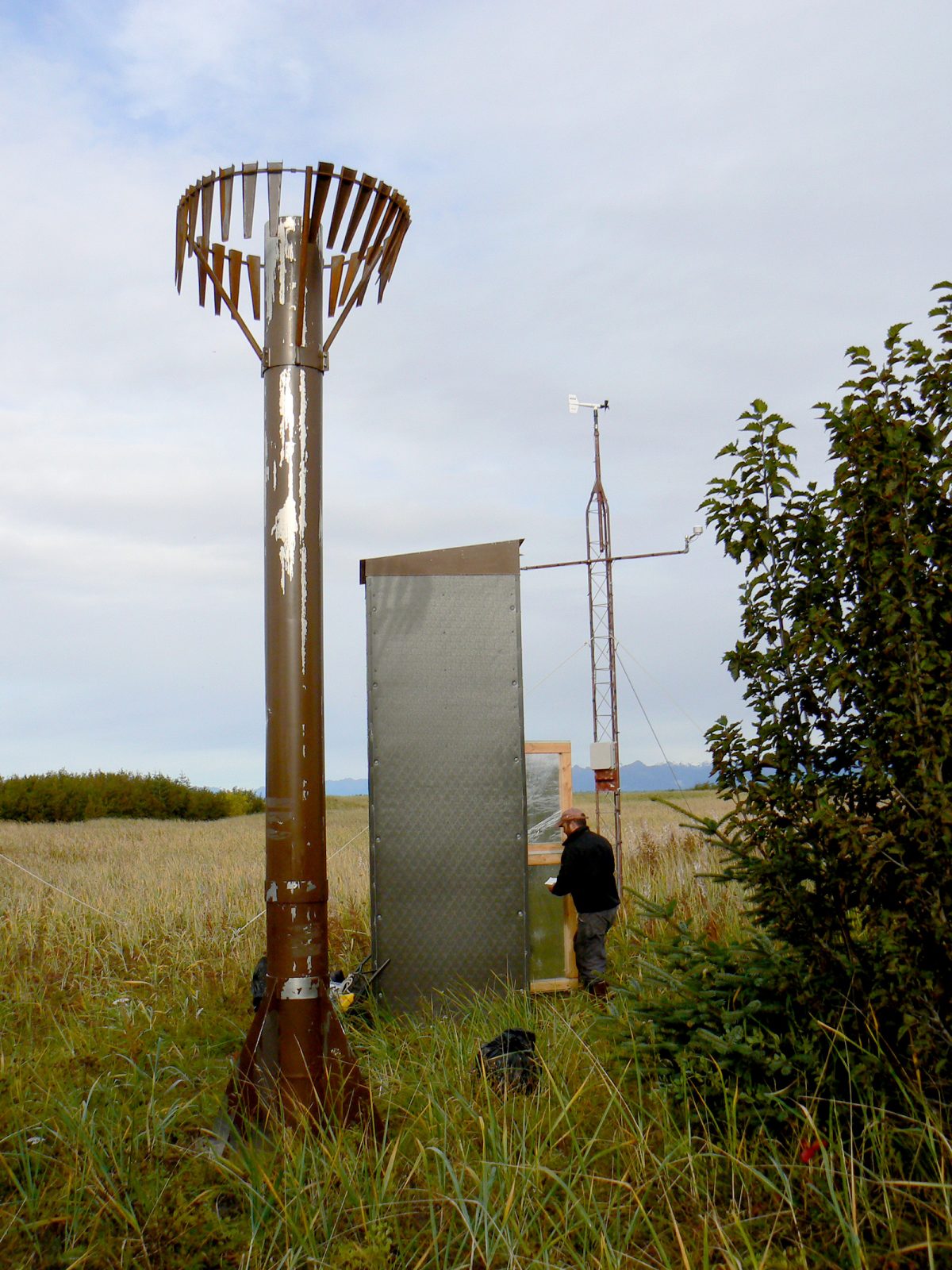
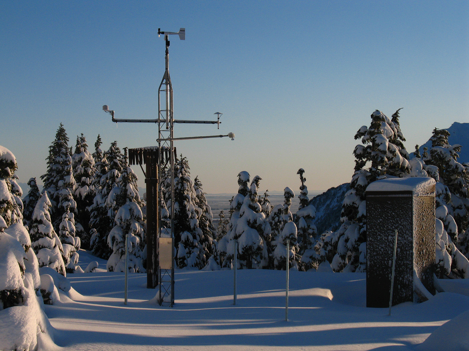
The configuration at each SNOTEL site is tailored to the physical conditions, climate, and specific requirements of the data users. A typical SNOTEL remote site consists of measuring devices and sensors, an equipment shelter for the radio telemetry equipment, an antenna and solar panels used to keep batteries charged. The data collected are generally reported multiple times per day, with some sensors reporting hourly. The SNOTEL sites are designed to operate unattended and without maintenance for a year or more. AOOS supports OSRI’s collaboration with NRCS to perform annual station visits and make any needed repairs and sensor or battery turnarounds.
Parameters measured as part of the AOOS/OSRI SNOTEL project include:
- temperature
- wind speed and direction
- precipitation
- solar radiation
Project Highlights
With several years of data now available, scientists are able to more quantitatively test their understanding of freshwater input into Prince William Sound and its influence on circulation. The record is long enough to also develop a regional climatology, an important tool for understanding long term climate trends and linking them to changes being observed in the local marine and terrestrial environments.
In order to optimize resources and make sure the stations are best meeting user needs, AOOS and OSRI launched a survey in 2011 about which weather stations/webcams were most important to users. This survey helped determine which SNOTEL sites to continue servicing. In addition to climatology work, SNOTEL data get regular use by local aviation and marine users. OSRI and AOOS typically get immediate reports from stakeholders about stations that go down or are no longer reporting real time information.
Funding Sources and Partners
> Natural Resources Conservation Service (NRCS)
> Oil Spill Recovery Institute (OSRI)
Resources
- Oil Spill Recovery Institute
- Prince William Sound Science Center
- NRCS SNOTEL Information Links:
Principal Investigators

Oil Spill Recovery Institute