Central Beaufort Sea Wave and Hydrodynamic Modeling Study
Foggy Island Bay/Stefansson Sound
-

Photo: BOEM North Slope ShoreZone survey, in the Beaufort Sea, Alaska. August 2012. 70 23.720 N 147 31.171 W, McClure Islands, outer Stefannson Sound. Photo credit: Mandy Lindeberg and Shorezone.
Motivation
Renewed interest in nearshore oil exploration and production in the central Beaufort Sea has created a general need to advance understanding of the existing wind, wave, current, storm, and sediment dynamics conditions in this Beaufort Sea coastal region. The particular study described here was prompted by the 2015 submission of a Development and Production Plan (DPP) by Hilcorp Alaska, LLC (HAK) to develop the North Slope Liberty prospect in the eastern Beaufort Sea, east of Prudhoe Bay in the Stefansson Sound region (Figure 1).

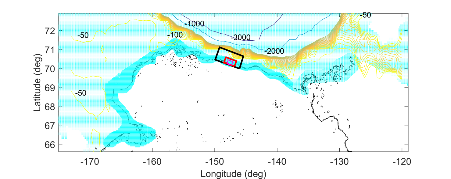
Figure 1. Map of Alaska, USA. The study area is situated in the Beaufort Sea just east of Prudhoe Bay along the North Slope.
The Liberty Development Project will include the construction of an artificial drilling and production island and burial of a sub-seabed pipeline to convey oil from the artificial island to an overland pipeline south of the artificial island.
Stefansson Sound and Foggy Island Bay, though in the vicinity of the well observed area around Prudhoe Bay, are difficult to model due mainly to the scarcity of wind and wave information there, complex shallow bathymetry and coastal topography, and highly variable sea ice conditions. Given the anticipated changes in offshore marine conditions for the region, the overreaching goal of this study is to improve wave and hydrodynamic model capabilities for the area and provide a database of skill-tested model outputs around and within Stefansson Sound. Assembling historical data, selectively needed new observations and numerical model hindcasts and forecasts into a single data portal will result in an up-to-date database invaluable for future environmental assessments in the Beaufort region, and will inform assessment and documentation of the hydrodynamic forcing mechanisms, sediment transport conditions, seasonal water quality, plume monitoring of turbidity and suspended sediment concentrations in the region.
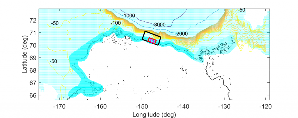
Though the focus of the hydrodynamic modeling undertaking will lie within the nearshore areas of Stefansson Sound and in particular Foggy Island Bay, the effort will subsequently collect wave model data for the entire model domain (Figure 2). The overall results will help document past and present-day wave conditions and will allow predictions of how current wave conditions may change over the life of any planned or proposed offshore activities (1–30 years).
The project is expected to address how more pervasive periods of less sea ice, longer periods of open water, and changes in ocean and atmospheric temperatures may lead to changes in wave and storm surge conditions, greater coastal erosion rates and impacts to the design of offshore structures leading to potential changes in field logistics and marine operations.
Study Area
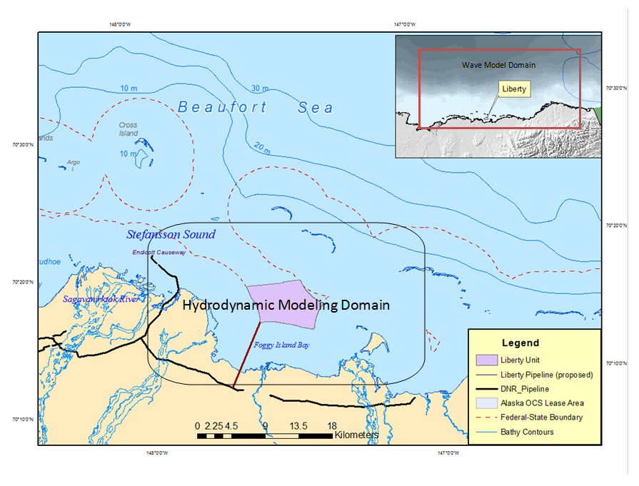
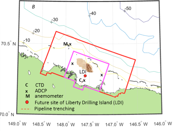
Figure 2. Map showing the Foggy Island Bay and Stefansson Sound area where the Liberty Development Project is proposed and the study model domain.
The box shown in Figure 2 encircles the proposed extent of the wave model domain covering the deep and shallow water areas of the central and eastern Beaufort Sea. Also shown is the proposed general area where the high resolution hydrodynamic modeling and much of the anticipated new field observations as part of this project work will be conducted.
Goals
There are seven primary goals for this project:
1. Through the development and use of a wave and a hydrodynamic model for the area encompassing Stefansson Sound and Foggy Island Bay and field measurements to validate the model outputs, assess the present day physical processes to include wind, waves, currents and sediment transport conditions.
2. Document the physical processes related to wave generation and dissipation through a combination of measured data and model results.
3. Document waves’ surface processes such as from white capping, the dissipation of waves due to bottom friction, and depth-induced wave breaking conditions.
4. Document the major causes of coastal erosion and timing of the major storm events; Include impacts from breaking waves and storm surge from longer periods of open water.
5. Document the waves, currents, and sediment dynamics from the potential construction and placement of man-made structures within the Foggy Island Bay area; related to offshore construction of a drilling island, burial and construction of a sub-seabed pipeline.
6. Produce a forty-year wind /wave hindcast reanalysis dataset (~1979–2019).
7. Forecast changes in wind-waves over a thirty-year time frame, starting with 2 years, 5 years, 10, 20 and then 30 years (~2019–2049).Through field observations, historical and new, the ultimate goal is to be able to adequately document wave and sediment transport conditions within Stefansson Sound/Foggy Island observationally and provide input data assimilation and validation support for project modeling activities (Figures 3 and 4). Before the modeling efforts begin, the team will compile a historical data record to establish an annotated spatial database and bibliography that will summarize relevant historical information gathered from publically available data and published documents. This will help identify additional data needs, from which a field sampling plan will prioritize any new measurements needed to achieve the project goals. New observations may include any of the following measurements in the immediate vicinity of Foggy Island Bay and Stefansson Sound:
- bottom topography (bathymetry)
- meteorological conditions
- ice conditions
- waves and current
- water level
- storm surge
- water quality measurements of turbidity
- laboratory analyses of total suspended sediment (TSS)
- sediment transport dynamics.
- Figure 3. The proposed Liberty Project Drilling Island adjacent to the Boulder Patch, a unique and productive high latitude kelp habitat.
- Figure 4. Preliminary bounds of the proposed nested model grids.
A website with an active data portal dedicated to the Beaufort Sea project area will be maintained throughout the project and hosted by the AOOS data portal system. The website will be updated quarterly and will present how the project is progressing, and will include links to the annotated bibliography, model output summaries and project milestone status updates and results. The interactive data portal will allow users to visualizes multiple layers of information on a regional map, will serve downloadable files and deliver real-time measurements across the region, including any new observations being collected as part of this study. Currently active real-time station data are already available on the Arctic Data Portal, hosted by AOOS.
Other Regional Activities and Observations
Long term meteorological data from the region are available from the Barrow and Deadhorse Airports. There is a multi-year water level record from the one National Oceanographic and Atmospheric Administration (NOAA) tide gage on the U.S. Beaufort Sea coast in Prudhoe Bay (NOAA, 2008) (Figure 5). All real-time data are available via the AOOS website: legacy.aoos.org
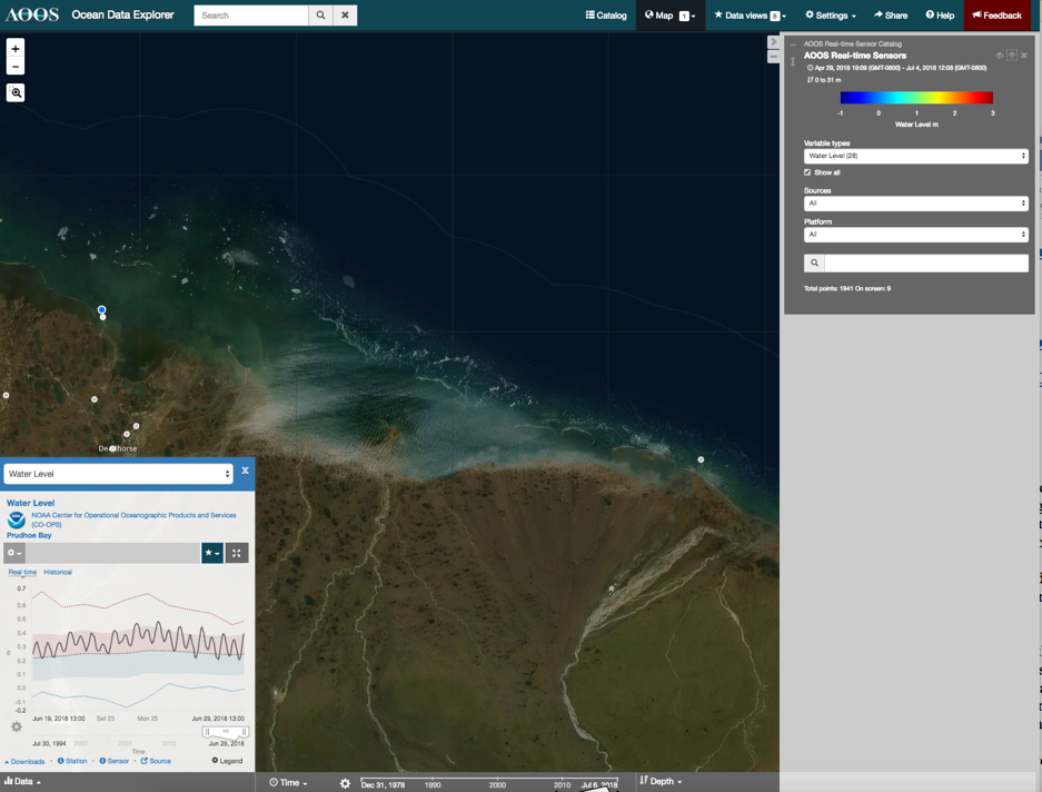
- Figure 5. AOOS data portal map image of the central Beaufort Sea spanning the study area for this project, showing with a graph the Prudhoe Bay real-time NOAA CO-OPS NWLON tide gauge station data (station blue dot within red circle).
The USGS (US Geological Survey) is currently developing a coupled wave/hydrodynamic-sediment transport model for application to their ongoing work on coastal erosion in the
Kaktovik region. For more details, please visit: https://geology.usgs.gov/postdoc/profiles/erikson/index.html
This project is directly relevant to other studies in the region including the recently funded Long-term Ecological Research (LTER) Beaufort Sea Lagoons (Figure 6). The Foggy Island project lead Jeremy Kasper is co-PI on the 5+ year NSF funded LTER effort aimed at understanding how exchange between barrier island fringed lagoons (including Stefansson Sound) and areas offshore of the barrier islands controls ecosystems in the sheltered lagoon systems. Sensors deployed as part of the LTER by Kasper will be leveraged for this project, while new observations made during this effort will inform analyses for the LTER. For more information on the LTER Project, refer to: https://lternet.edu/site/beaufort-lagoon-ecosystem/

- Figure 6. Schematic of major lagoon system components (labeled black) and tools (labeled red) that will support Beaufort Lagoon Ecosystems LTER research. For more details, please visit: https://ble.lternet.edu/about (Image courtesey: Kenneth Dutton, University of Texas, Austin)

- Photo: Ice floe with polar bear in Beaufort Sea.
Image ID: arct1099, 17 August 2012
NOAA At the Ends of the Earth Collection
Photo Credit: Crew and Officers of NOAA Ship FAIRWEATHER